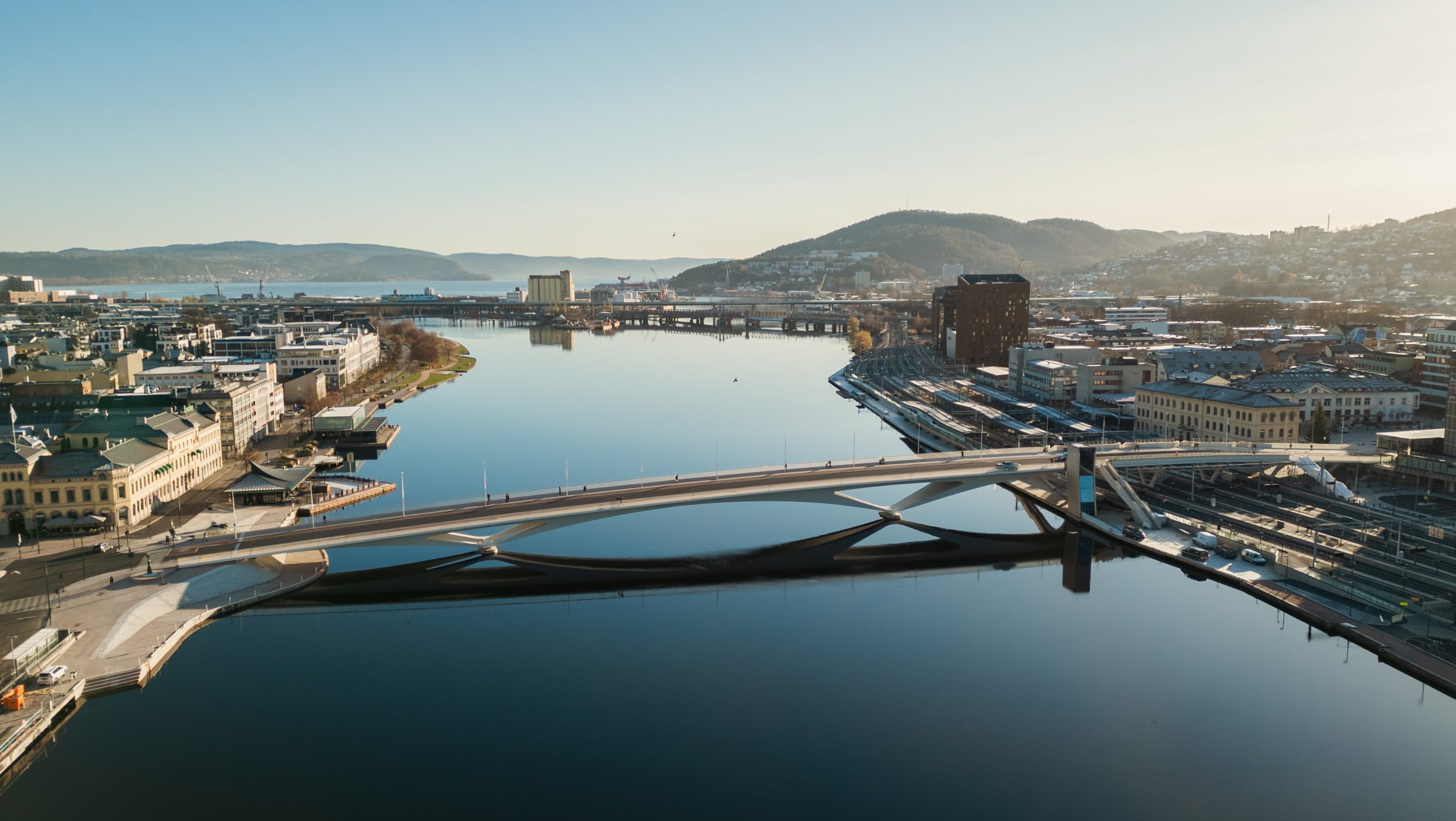
Drammen City Bridge

| Categoria | Projectos de Infraestruturas |
|---|---|
| Ano | 2026 |
| País | Benelux |
| Organização | Degree of Freedom |
| Parceiros do Projeto | Saaha, Knight Architects, Norconsult, Asplan Viak |
| Autor | Degree of Freedom |
| Cliente | Drammen kommune |
| Local de construção | Drammen, Noorwegen |
| Tags |
Projectbeschrijving
De brug van Drammen, die de districten Strømsø en Bragernes met elkaar verbond, was bijna 90 jaar in gebruik toen de gemeente besloot tot vervanging ervan. De ernstige aantasting van de betonnen constructies en het einde van hun technische levensduur, gecombineerd met de noodzaak om het centrale treinstation uit te breiden door de spoorlijnen met 0,50 meter te verhogen, maakten een volledige vervanging onvermijdelijk.
De nieuwe Stadsbrug van Drammen vormt een mijlpaal voor de stad. Ze fungeert als de belangrijkste stedelijke verbindingsas en toont hoe de BIM‑methodologie, in combinatie met geavanceerde parametrische modelleertechnieken, het mogelijk maakt complexe infrastructuurprojecten uit te voeren met een vlotte samenwerking tussen meerdere disciplines en internationale teams.
Technische kenmerken
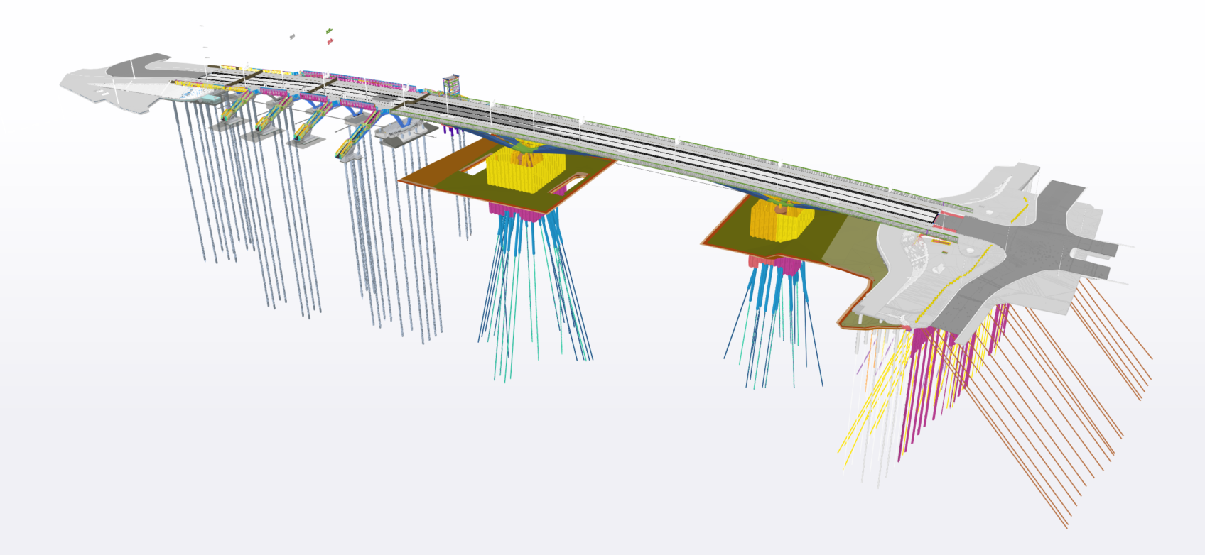
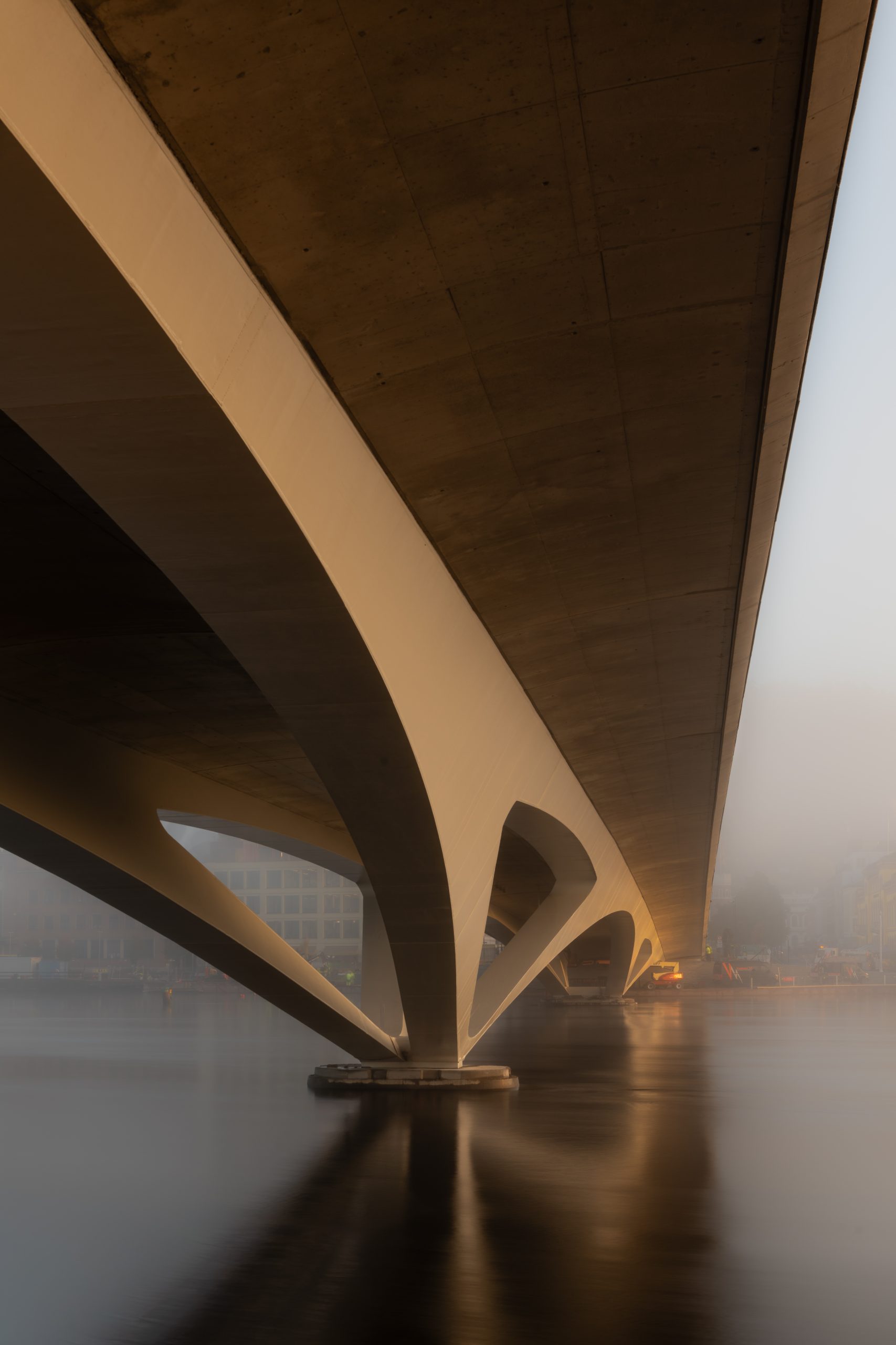
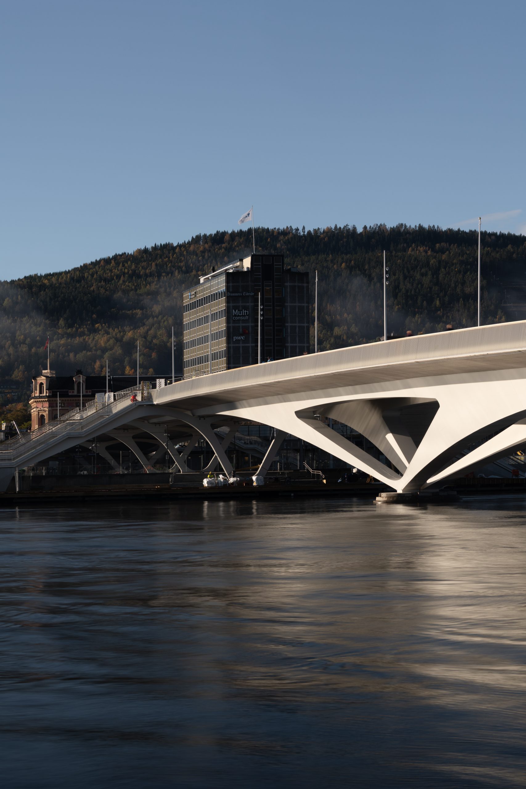
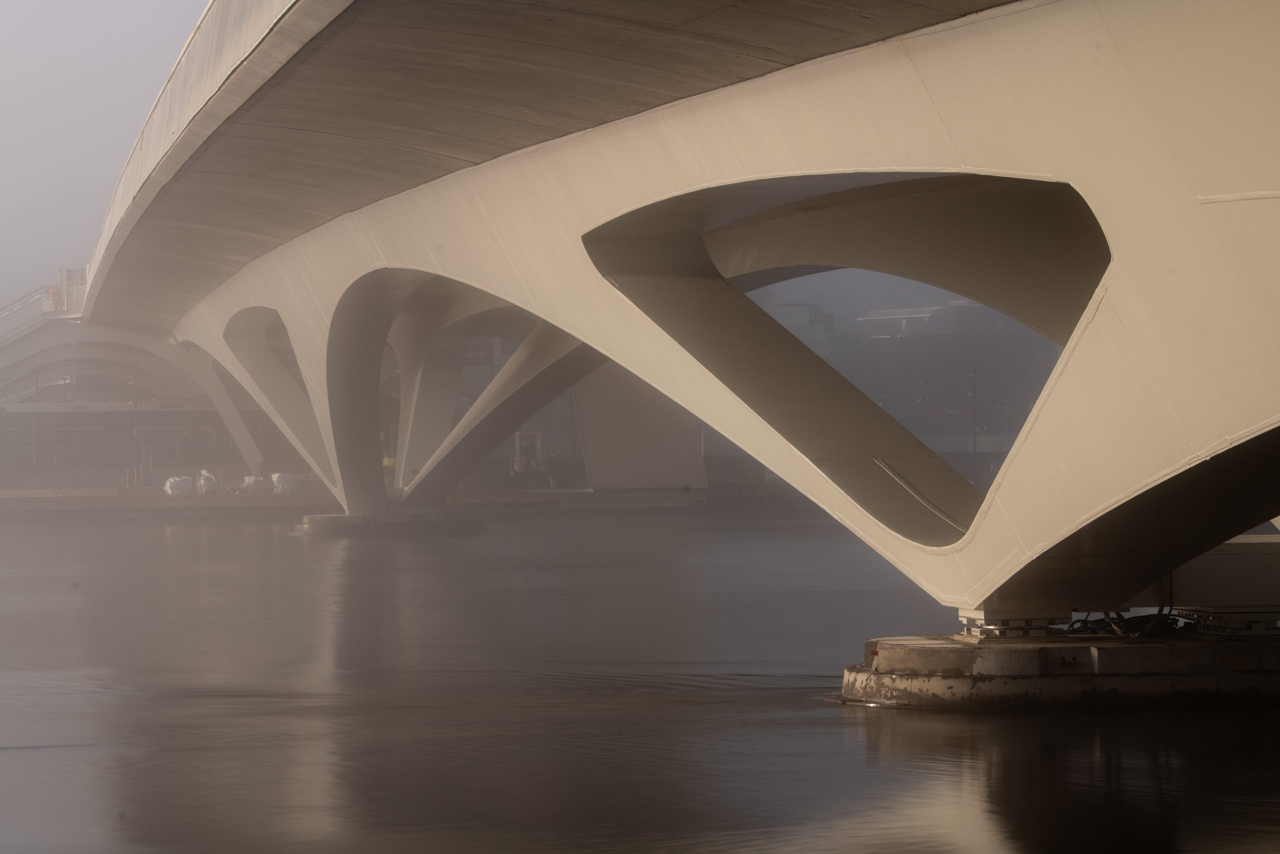
De brug heeft een totale lengte van 262 meter en overspant zowel de rivier Drammenselva als het treinstation. De constructie bestaat uit twee duidelijk onderscheiden delen: de overspanning over de rivier en de overspanning over de spoorinfrastructuur.
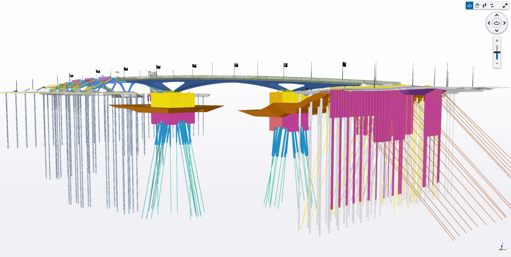
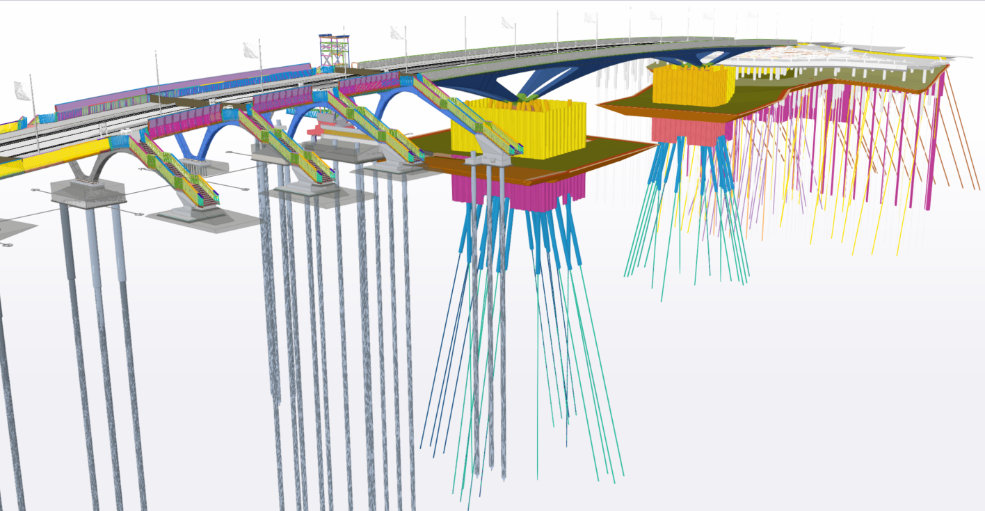
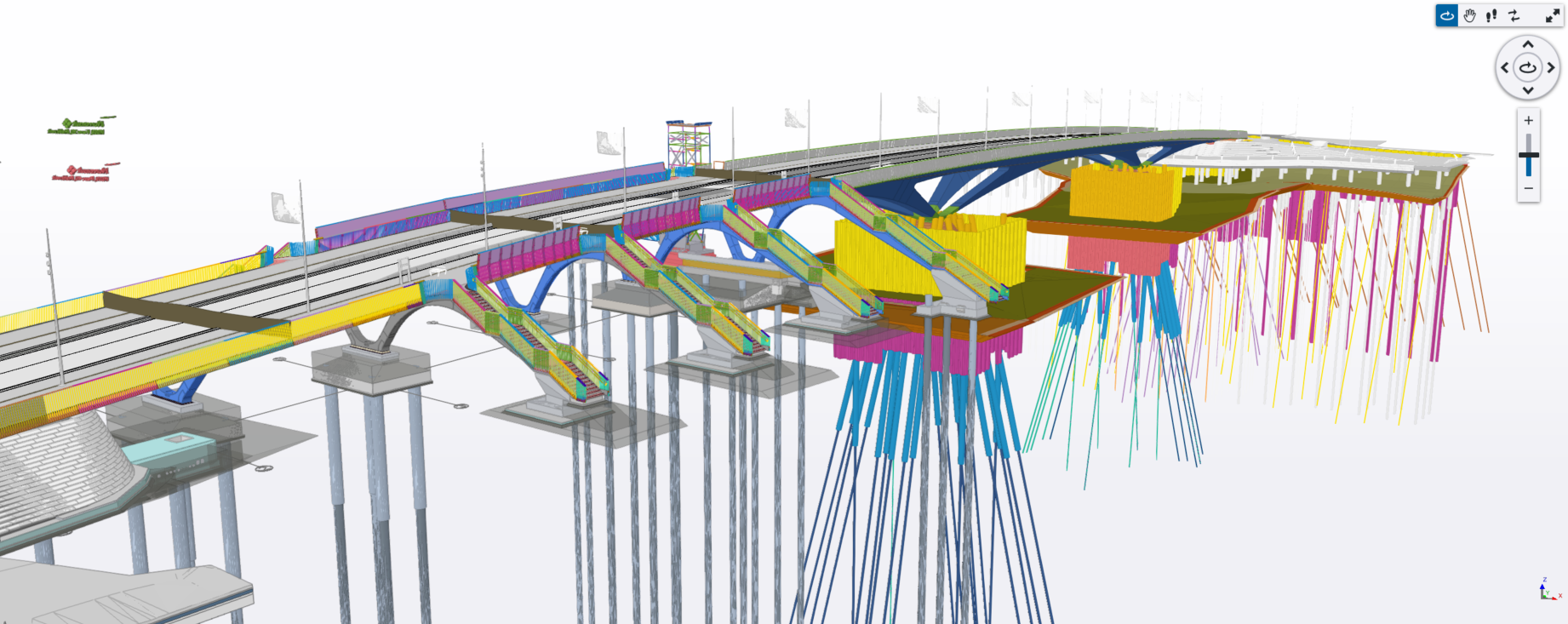
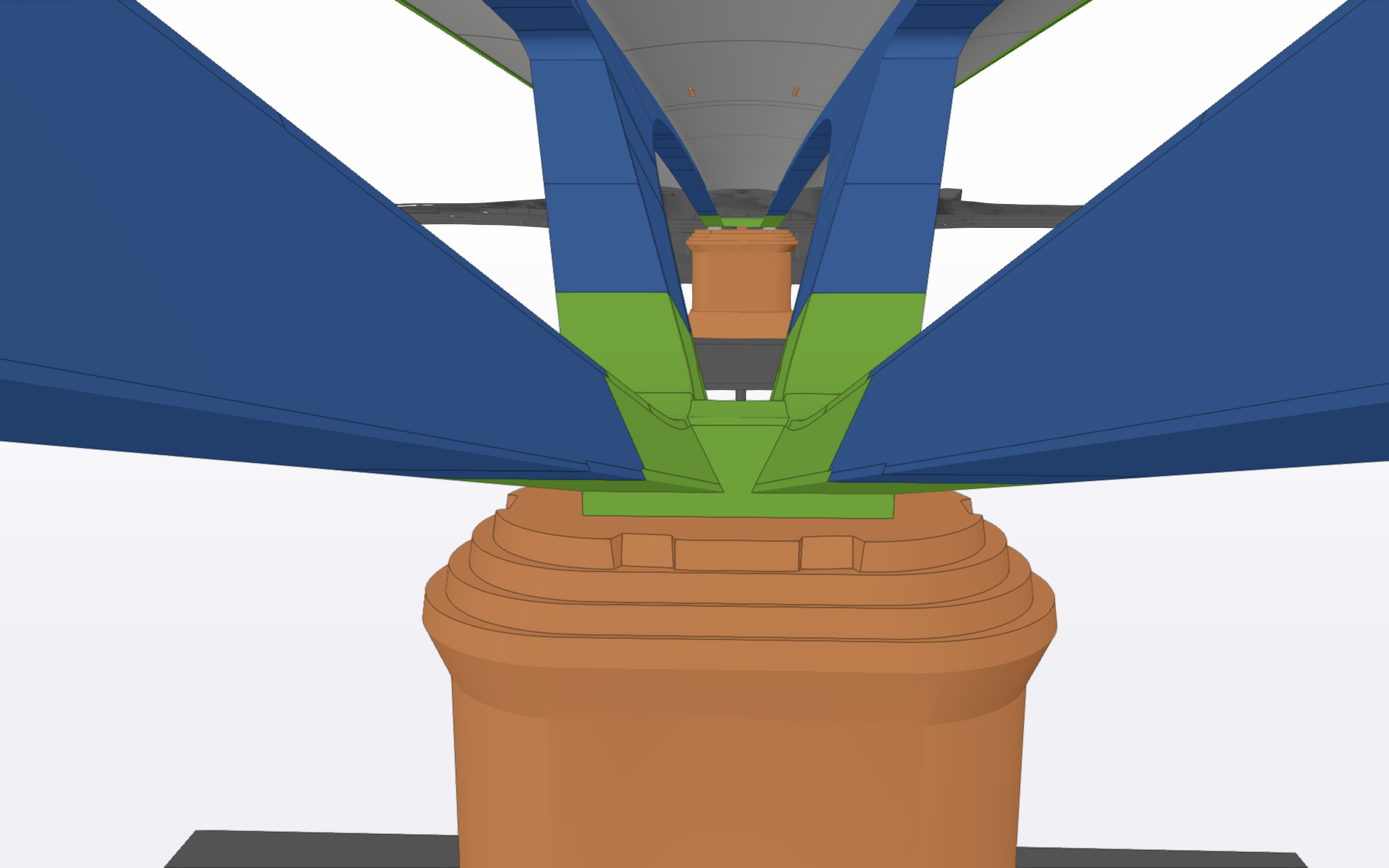
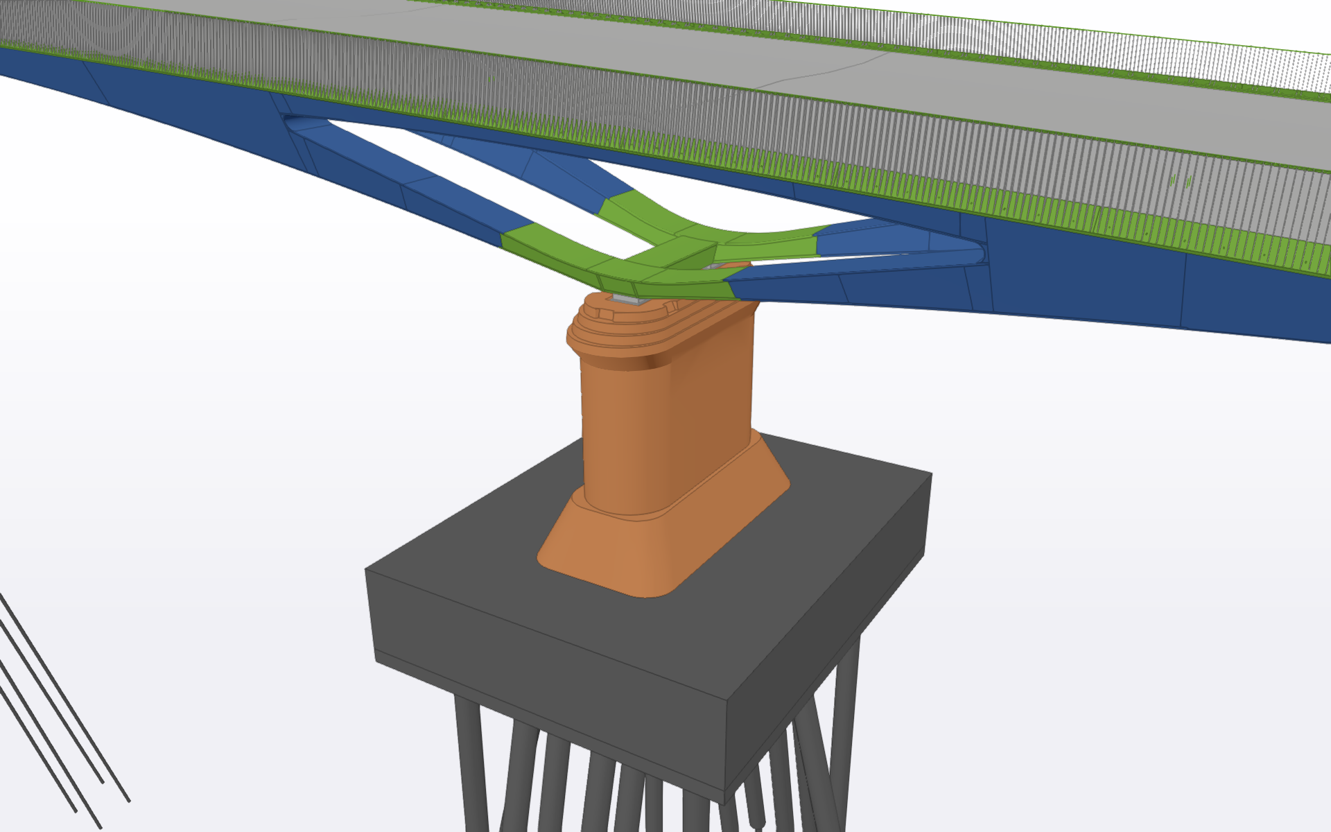
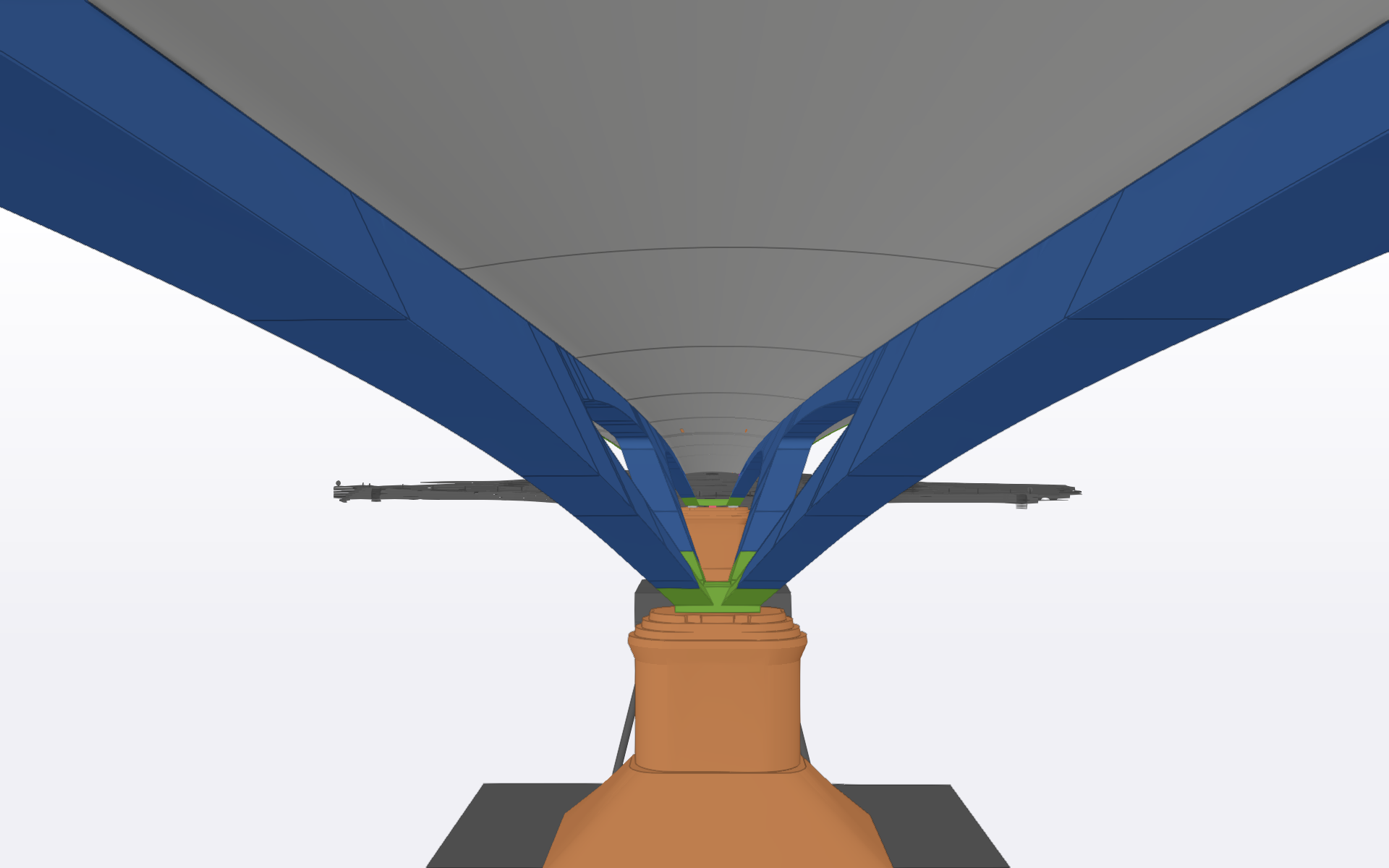
Het gedeelte boven de rivier wordt gerealiseerd met drie hoofdoverspanningen van respectievelijk 46 m, 86 m en 42 m. Het draagstructuursysteem bestaat uit metalen stalen bogen met een variabele hoogte, die de belastingen overbrengen naar een gewapende betonnen brugdek, dat fungeert als dragend en verdelend element. De fundering bestaat uit stalen heipalen die tot het competente rotsige substraat worden geheid, met dieptes van ongeveer 75 tot 80 m, waardoor een correcte overdracht van de belastingen naar de ondergrond gegarandeerd is.
In de zone boven de spoorlijnen wordt de structurele continuïteit verzekerd door vijf bijkomende, kleinere overspanningen met lengtes tussen 11 m en 19,5 m, die geïntegreerd zijn in het globale structurele geheel.
Het brugdek, met een breedte van 19 meter, omvat twee rijstroken (voor bus en taxi) en afzonderlijke zones voor voetgangers en fietsers van respectievelijk 5 en 7 meter. Deze multimodale aanpak sluit aan bij hedendaagse principes van duurzame en inclusieve stedelijke mobiliteit.
Fundamenten van parametrisch modelleren
De BIM‑strategie van het project draaide rond de ontwikkeling van een geavanceerd parametrisch model van de bovenbouw met behulp van Rhinoceros en Grasshopper. Dit was geen loutere softwarekeuze, maar een strategisch engagement voor geometrische intelligentie en operationele flexibiliteit.
Het parametrische model werd zo opgezet dat het dynamisch gekoppeld kon worden aan meerdere externe databronnen: het tracé van de weg zoals gedefinieerd door de verkeersingenieurs, de architecturale geometrie vastgelegd door de ontwerpers, en de aangrenzende structurele systemen zoals funderingen. Deze multibron‑afhankelijkheidsstructuur maakte snelle aanpassingen mogelijk gedurende de volledige levenscyclus van het project.
Naast de puur geometrische definitie fungeerde het parametrische kader als een essentiële analytische tool voor het structureel ontwerpteam. Het analyseren van complexe driedimensionale vormen in traditionele analysetools bracht aanzienlijke uitdagingen met zich mee. Het parametrische model genereerde tussenliggende geometrieën en coördinatiereferenties die de structurele ingenieurs rechtstreeks ondersteunden en de analyse van deze complexe structuren vergemakkelijkten.
Multidisciplinaire coördinatie
Het project bracht meer dan tien verschillende engineering‑ en ontwerpdisciplines samen, waaronder architectuur, constructies, technieken (MEP), geotechniek, wegenbouwkunde, landschapsontwerp, topografie en andere specialisaties. De teams waren geografisch verspreid over meerdere landen, wat aanzienlijke coördinatie-uitdagingen met zich meebracht.
De BIM‑coördinatiestrategie was gebaseerd op een uniform gezamenlijk dataplatform (CDE). Elke discipline werkte haar modellen uit in de eigen native software, zoals AutoCAD, Revit, Tekla Structures en Navisworks, waarna deze werden geëxporteerd in IFC‑formaat. De afzonderlijke modellen werden vervolgens geïntegreerd in één globaal referentiemodel.
Deze collaboratieve BIM‑aanpak verhoogde de projectkwaliteit aanzienlijk door conflicten in vroege fases te detecteren en op te lossen, ontwerpfouten te reduceren via integrale systeeminzichten en de afstemming tussen disciplines in alle ontwikkelingsfasen te garanderen. Een dergelijk niveau van coördinatie zou met traditionele documentatie en 2D‑plannen vrijwel onmogelijk zijn geweest.
Continue ondersteuning en adaptief modelleren
De BIM‑betrokkenheid van het team eindigde niet bij het afronden van het ontwerp. Tijdens de uitvoeringsfase bleven de parametrische en gedetailleerde modellen levende projectmiddelen, die continu werden aangepast om keuzes van de aannemer, beslissingen rond levering en reële werfcondities te weerspiegelen.
De technische ondersteuning omvatte het leveren van kritische geometrische parameters voor uitzetting en topografische controle, waaronder de positionering van ankers en montagemarkeringen. Daarnaast werden de uiteindelijk gekozen bouwsystemen en materialen geïntegreerd in het model, samen met voortdurende updates van de technische specificaties op basis van inkoopbeslissingen. Ook werd ondersteuning geboden bij het definiëren van de uitvoeringsvolgorde, wat de coördinatie tussen disciplines vergemakkelijkte. Deze voortdurende technische begeleiding zorgde ervoor dat het model gedurende de volledige uitvoeringsfase een betrouwbare en actuele referentie bleef.
De Stadsbrug van Drammen toont exemplarisch hoe de BIM‑methodologie, gecombineerd met geavanceerd parametrisch modelleren, de projectresultaten in alle fasen van ontwerp, coördinatie en uitvoering aanzienlijk verbetert. Van ongekende geometrische complexiteit, via systematische multidisciplinaire samenwerking tussen meer dan tien specialisaties in drie landen, tot adaptieve uitvoeringsondersteuning gebaseerd op as‑built‑gegevens: dit project onderstreept het transformerende potentieel van een doorgedreven BIM‑implementatie. Het vormt een referentie voor de realisatie van complexe infrastructuurprojecten via digitale, collaboratieve processen die de kwaliteit verhogen, risico’s beperken en uiteindelijk betere resultaten opleveren voor steden, betrokken partijen en gemeenschappen.
Project Description
The existing Drammen Bridge, connecting the districts of Strømsø and Bragernes, had been in service for nearly 90 years when the municipality decided to replace it. The severe deterioration of its concrete structures and the fact that the bridge had reached the end of its service life, combined with the need to expand the central railway station by raising the tracks by 0.50 metres, made complete replacement unavoidable.
The new Drammen City Bridge represents a new landmark for the city, serving as the main axis of urban connectivity and demonstrating how BIM methodology, combined with advanced parametric modelling techniques, enables the delivery of complex infrastructure projects while maintaining seamless collaboration across multiple disciplines and international teams.
Technical Characteristics
The bridge has a total length of 262 metres and spans both the Drammenselva river and the railway station. The structure is divided into two distinct structural zones: the river crossing and the railway crossing.
The river crossing comprises three main spans of 46 m, 86 m and 42 m respectively. The structural system consists of steel arches with variable depth, transferring loads to a reinforced concrete deck that acts as both a support and load-distribution element. The foundations are formed by driven steel piles reaching competent bedrock at depths of approximately 75 to 80 metres, ensuring proper load transfer to the ground.
In the section crossing the railway, structural continuity is achieved through five additional spans of smaller scale, with lengths ranging from 11 m to 19.5 m, integrated into the overall structural system.
The 19-metre-wide deck accommodates two traffic lanes (bus and taxi) along with dedicated pedestrian and cycling paths of 5 and 7 metres respectively. This multimodal approach responds to current principles of sustainable and inclusive urban mobility.
Parametric Modelling Principles
The BIM strategy of the project was centred on the development of a sophisticated parametric model of the superstructure using Rhinoceros and Grasshopper. This was not simply a software choice, but a strategic decision to embed geometric intelligence and enable operational flexibility.
The parametric model was designed to dynamically link to multiple external data sources: the road alignment defined by transport engineers, the architectural geometry established by designers, and adjacent structural systems, including foundations. This created a model driven by multiple data sources, enabling agile adaptation throughout the entire project lifecycle.
Beyond purely geometric definition, the parametric framework acted as an essential analytical tool for the structural design team. The management of complex 3D geometries within traditional analysis platforms posed significant challenges. The parametric model generated intermediate geometries and coordination references that directly supported structural engineers, facilitating the analysis of these complex structures.
Multidisciplinary Coordination
The project brought together over ten engineering and design disciplines, including architecture, structures, MEP, geotechnics, road engineering, landscape design and surveying. The teams were geographically distributed across multiple countries, posing significant coordination challenges.
The BIM coordination strategy was based on a Common Data Environment (CDE). Each discipline developed its models within its native platform, such as AutoCAD, Revit, Tekla Structures and Navisworks, before exporting them in IFC format. These individual models were then integrated into a single federated model serving as a shared reference.
This collaborative BIM approach significantly improved project quality by identifying and resolving conflicts at early stages, reducing design errors through holistic system visibility, and ensuring alignment across disciplines throughout all phases of development. Achieving this level of coordination using traditional documentation and 2D drawings would have been virtually impossible.
Continuous Support and Adaptive Modelling
The team’s BIM involvement did not end with the completion of the design phase. During construction, the parametric and detailed models remained active project assets, continuously updated to reflect contractor decisions, procurement choices and actual site conditions.
Technical support included the extraction and provision of critical geometric parameters for setting-out and topographic control, including anchor positions and assembly references. The model was also updated to incorporate the construction systems and materials ultimately adopted by the contractor, alongside continuous updates to technical specifications based on procurement decisions. In addition, support was provided in defining construction sequences, facilitating coordination between disciplines. This continuous involvement ensured that the model remained a reliable and up-to-date reference throughout the execution phase.
The Drammen City Bridge exemplifies how BIM methodology, combined with advanced parametric modelling, significantly enhances outcomes across all phases of design, coordination and construction. From highly complex geometries, through systematic multidisciplinary coordination across more than ten disciplines in three countries, to adaptive construction support based on as-built data, the project demonstrates the transformative potential of a sophisticated BIM implementation.
It sets a benchmark for the delivery of complex infrastructure through collaborative digital processes that enhance quality, reduce risk and ultimately deliver better outcomes for cities, stakeholders and communities.


Deixe o seu comentário
A Construsoft é revendedor autorizado de Tekla Structures e disponibiliza formação, suporte técnico e outros serviços aos seus clientes.
Para mais informações, visite nosso site:
construsoft.ptTekla is a Trimble Company © Copyright 2026 Tekla